Natural Borders
Imagine yourself above the West Coast of the United States looking down on the land that spans the border of Northern California and Southern Oregon. This is where the Siskiyou, Cascade and Klamath mountain ranges converge to create an area of outstanding biological diversity. An amazing variety of plants and animals thrive in the forests, alpine meadows and steep canyons of these mountains.
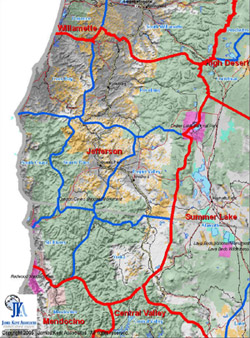 Human Geographic Map of the State of Jefferson
Fertile valleys are home to buffalo ranches, acres upon acres of fruit and nut orchards as well as miles of rolling vineyards. Towns, large and small are nestled in the foothills. The deep canyons, forests, valleys and watersheds along with the cultural traditions and social structures of the people who live here define the NATURAL BORDERS of this region. In political terms, this is the border between California and Oregon. In HUMAN GEOGRAPHIC terms, it is known as the great State of Jefferson. We did not discover the State of Jefferson. In fact it has a rich history dating back to the 1880s. But we are the first to map the cultural and social boundaries along with the natural geographic attributes of the area.
This alternative mapping system that treats the land and people as one unit is called HUMAN GEOGRAPHIC MAPPING.
Why Human Geographic Mapping?
Traditional geopolitical maps create arbitrary lines across the landscape. They do not reflect the natural borders created by the social, cultural, economic and ecological systems (bio-social ecosystems) of a region. Yet for effective policy and project development, the land and the people who live on it must be seen, mapped and understood as one unit. You can read our policy paper on "Climate Change and the Language of Geographic Place" which makes the case that policy development based on human geographic units will make efforts to deal with climate change more effective.
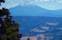 Mount Shasta, California as seen from Mount Ashland, Oregon. The cultural and social traditions tied to this land transcend the geopolitical boundaries (the border between California and Oregon) of traditional mapping.
Human Geographic Maps depict specific bio-social ecosystems and portray the attachment people develop to each other and to the land where they live and work. Social, cultural and economic routines along with the geographic features of an area distinguish one population or cultural area from another.
The importance of these maps is to see that people have habitat boundaries that do not correspond to the arbitrary boundaries that govern our formal systems. Policies and projects developed using political maps alone are not sensitive to people's attachment to the land and result in fragmented governance. Human Geographic Maps depict the people and land as one inseparable unit and are therefore highly enhanced tools for day-to-day management, long-range planning, NEPA (National Environmental Policy Act) documentation and culture-based marketing.
 Human Geographic Units
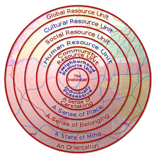
Human Geographic Mapping results in a holistic description of social, cultural and economic trends of a geographical area. This information is organized into 6 scales of human geography from the smallest neighborhood to planet-wide, global systems. These units reflect how residents view their own territory and have proven useful as planning and administrative tools because they match how residents actually relate to their landscapes.
Neighborhood Resource Units
Community Resource Units
Human Resource Units
Social Resource Units
Cultural Resource Units
Global Resource Units
Human Geographic Mapping - Where do we go from here? |
|
| Natural Borders, LLC. | Issue Management System |
Cobalt Web Designs