Table of Contents Next Chapter   
Natural Borders Homepage

A Human Geographic Issue Management System for

Natural Resource Managers in the

Willamette Valley, Oregon


Chapter One

Project Background Report


Background and Objectives


Management of federal forest lands of the Pacific Northwest has undergone significant change in the last fifteen years. In the Willamette River Valley, timber production from public lands is a fraction of what it once was, and recreational uses have been growing steadily. The urban areas surrounding public lands are growing in substantial ways, while the rural communities near them are continuing to struggle economically with the shift away from timber toward a recreation economy and an urban-oriented labor base. Meanwhile, management budgets are shrinking and skilled personnel are being lost. Without a budget driven by timber receipts, land management agencies have to "do more with less."


In this climate of changing management conditions, the Willamette National Forest, in conjunction with the Siuslaw National Forest and the Eugene and Salem District Offices of the Bureau of Land Management, used the services of James Kent Associates (JKA) to conduct social and economic research in the human communities associated with the Forest. Forest management wanted direct information from these communities about the social and economic trends observed by residents, the current orientation of residents toward public land, specifically the issues they have about natural resources and the opportunities they see for resolving them. In addition, the Forest wanted advice about how to communicate effectively with a broader range of publics so that it can foster greater dialogue and collaboration between Forest staff and community residents.


The specific objectives of the Willamette Human Geographic Mapping Project were to:


1. Use the Discovery Process in the Greater Salem, Mid-Valley, and South Willamette Human Resource Units (HRUs) to describe the publics, networks, settlement patterns, work routines, supporting services, recreational activities, and geographic boundaries. The products of Discovery are:


a.      A human geographic map, at two scales of geography, which reflects the culture of the local area and the identity residents have with their landscape.


b.     Description of key informal networks and network caretakers in each HRU;


c.      The range (emerging, existing, disruptive) of actionable citizen issues related to natural resource management and biosocial ecosystem recovery;


d.      Strategies in each HRU for culturally-appropriate communication (who, when, where, how);

e.      Current and future social and economic trends affecting each HRU, with implications derived for "desired future conditions" useful for land use planning efforts;


f.      Opportunities identified by citizens to resolve issues, to create productive harmony (as called for in NEPA) between physical and social environments, and to develop citizen ownership in public land management through community-based partnerships;


2. Use social, economic, and cultural information obtained through the Discovery Process to develop a Geographic Information System (GIS) data layer. This data layer is expected to complement the traditional bio-physical data employed by the BLM and the Forest Service in order to broaden the ability of the agencies 
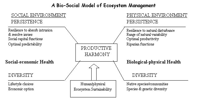
to deal with both bio-physical and social components of the ecosystem. Such a bio-social approach to ecosystem management will be realized through the following objectives:


a.      GIS development of human geographic maps for the three HRUs at two scales of geography, the HRU and the Community Resource Unit (CRU);


b.     Aggregation of 1990 and 2000 Census data (as available) according to HRU boundaries in order to identify social and economic trends at appropriate cultural scales;


c.      Integration of quantitative census data with qualitative social and economic data of the Discovery Process in order to present a holistic picture of local communities for attachment as a database to the map layer. This documentation will be useful for NEPA, land use planning, and day-to-day management;


d.      Identification of communication strategies, attached to the map layer, that will show how, with whom, when and where to communicate at the informal level of community.


e.      Provision of a summary report that shows the framework of a Human Geographic Issue Management System (HGIM)™ on the basis of the community fieldwork (The Discovery Process) and the GIS social layer. Such a framework is designed to identify citizen issues at the emerging stage of development, to promote staff capacity to respond in timely and appropriate ways, and to develop projects and policy capable of broad-based public support.


Teammates who participated in this fieldwork are:

Kevin Preister, Ph.D., Social Ecology Associates, James Kent Associates

Luis Ibanez, Licenciado, James Kent Associates

Megan Gordon, M.A. Anthropology, Oregon State University

Toby Keys, M.A. Anthropology, Oregon State University

Kirsten Saylor, M.A. Anthropology, Oregon State University

Armando Arias, Ph.D., Dean, Social and Behavioral Sciences Center, California State University at Monterey Bay.

James Kent, J.D., President, James Kent Associates


Mapping support was provided by Paul Zelus and Walt Bulawa at Map Associates LLP, Pocatello, Idaho. Team resumes are included in Appendix D.
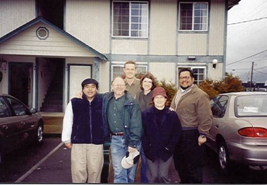


Figure One

Project Staff from left to right: Luis Ibanez, Kevin Preister, Toby Keys, Megan Gordon, Kirsten Saylor, and Armando Arias


 Methodology Used


The Discovery Process (tm) is a means to describe a community by "entering the routines" of that community in order to see the world as residents see it. Team members attend soccer games and school events, go to cafes, gas stations, laundromats, taverns and other gathering places. They are invited into people's homes. Following the adage, "People hate to be interviewed but love to talk," they get in situations where people tell stories about their community. They observe and interact with residents to determine their interests and concerns.


In practice, the JKA team contacted and listened to as many people as we could, to hear their stories of the land, their family history, changes they are seeing on the land and in their community, their use of public lands and ideas for improving management. We learned how public land management affects different kinds of people and what they think could be done to minimize the negative effects and enhance the positive ones. We always asked people who else we could talk with, and those people whose names came up several times we made a special point of contacting. In addition, we frequented the gathering places in the area - the restaurants, the laundromats, churches, and stores, engaging residents in conversation.


We made a point of talking with a wide variety of people - long time residents and newcomers, young and old, farmers, loggers, townspeople, environmentalists, commuters and storeowners. We talked to several kinds of recreationists - hunters, fishers, off-highway vehicle enthusiasts, campers, and hikers. Our contacts included officials from the many local, state, and federal agencies engaged in natural resource issues, staff from many social agencies, mayors, and city councilmembers.


In the Discovery Process, the team was particularly interested in the seven Cultural Descriptors, used by JKA as a community assessment methodology. The method is outlined in more detail in Appendix B. The Cultural Descriptors are as follows:

Geographic Boundaries: Any unique physical feature that defines the extent of a population's routine activities. Physical features generally separate the cultural identity and daily activity of a population from those living in other geographic areas. Geographic boundaries include geologic, biologic, and climatic features, distances, or any other characteristic that distinguishes one area from another. Examples of geographic boundaries include topographic features that isolate mountain valleys, distances that separate rural towns, or river basins that shape an agricultural way of life. Geographic boundaries may be relatively permanent or short-lived; over time, boundaries may dissolve as new settlement patterns develop and physical access to an area changes.


Settlement Patterns: The distribution of a population in a geographic area, including the historical cycles of settlement. This descriptor identifies where a population resides and the type of settlement categorized by its centralized/dispersed, permanent/temporary, and year-round/seasonal characteristics. It also describes the major historical growth/non-growth cycles and the reasons for each successive wave of settlement.


Publics: Segments of the population or a group of people having common characteristics, interests, or some recognized demographic feature. Sample publics include agriculturalists, governmental bodies, homemakers, industries, landowners, loggers, miners, minorities, newcomers, preservationists, recreationalists, senior citizens, small businesses and youth.


Networks: A structured arrangement of individuals who support each other in predictable ways because of their commitment to a common purpose, their shared activities, or similar attitudes. There are two types of networks, those that are informal arrangements of individuals who join together as a way to express their interests, and those that are formal arrangements of individuals who belong to an organization to represent their interests.  Networks functioning locally as well as those influencing management from regional or national levels are included in this descriptor.  Examples of citizen networks include ranchers who assist each other in times of need, grassroots environmentalists with a common cause, or families who recreate together. Examples of formal organizations include a cattlemen's association, or a recreational club.


Work Routines: The way in which people earn a living, including where and how. The types of employment, the skills needed, the wage levels, and the natural resources required in the process are used to generate a profile of a population's work routines. The opportunities for advancement, the business ownership pattern and the stability of employment activities are also elements of this descriptor.


Supporting Services: Any arrangement people use for taking care of each other, including the institutions serving a community and the caretaking activities of individuals. This descriptor emphasizes how supporting services and activities are provided. Commercial businesses, religious institutions, social welfare agencies, governmental organizations, and educational, medical and municipal facilities are all examples of support services. Caretaking activities include the ways people manage on a day-to-day basis using family, neighborhood, friendship or any other support system.


Recreational Activities: The way in which people use their leisure time. The recreational opportunities available, seasonality of activities, technologies involved, and money and time required are aspects of this descriptor. The frequency of local/non-local uses of recreational resources, the preferences of local/non-local users, and the location of the activities are also included. [1]


One product of using the Cultural Descriptors is an understanding of human geographic boundaries. People everywhere develop an attachment to a geographic place, characterized by a set of natural boundaries created by physical, biological, social, cultural and economic systems. This is called a Bio-Social Ecosystem. The term was created in 1991 by James Kent and Dan Baharav to integrate social ecology and biology in addressing watershed issues with people being a recognized part of the landscape. Unique beliefs, traditions, and stories tie people to a specific place, to the land, and to social/kinship networks, the reflection and function of which is called culture.


The first Human Geographic Maps (HGMs) came into existence in the late 1970s and early 1980s as part of JKA's work with the US Forest Service, Region 2, Forest Planning process. The USFS was looking for new and creative ways to empower citizens as part of the Forest Plans. The HGMs were published as a part of the Forest Plan implementation.


Seven different scales of cultural or human geography have been discovered. Operating at the proper scale brings optimum efficiency and productivity to projects, programs, marketing, policy formation and other actions by working within the appropriate social and cultural context.


1.       Neighborhood Resource Unit (NRU)

2.     Village Resource Unit (VRU)

3.     Community Resource Unit (CRU)

4.     Human Resource Unit (HRU)

5.     Social Resource Unit (SRU)

6.     Cultural Resource Unit (CuRU)

7.     Global Resource Unit (GRU)


The HGMs represent the culture of a geographic area, especially the informal systems through which people adapt to changes in their environment, take care of each other, and sustain their values and lifestyles. The HGMs represent the boundaries within which people already mobilize to meet life's challenges. Hence, their experiences are used through their participation as place-based knowledge to create ownership in issue resolution, project planning and implementation, public participation, and public policy development.


For this project, three scales of human geography were used, the Social Resource Unit (SRU), the Human Resource Unit (HRU), and the Community Resource Unit (CRU).


Social Resource Units (SRUs) are the aggregation of HRUs on the basis of geographic features of the landscape, often a river basin, for example, and are the basis of shared history, lifestyle, livelihood, and outlook. At this scale, face-to-face knowledge is much reduced. Rather, social ties are created by action around issues that transcend the smaller HRUs and by invoking common values ("We love the high desert.").


SRUs are characterized by a sense of belonging. These are rather large areas and one's perception as to the Unit's boundary is that when you cross the SRU boundary you are in an entirely different culture. There is a general feeling of "oneness" as being a part of this regional Unit. There is a general understanding and agreement on beliefs, traditions, stories and the attributes of being a part of the Unit.


JKA was directed to conduct research in the urban areas of Salem, Albany, Corvallis, Eugene, and Springfield, and the surrounding rural areas as well, from the crest of the Cascade Mountains to the crest of the coastal range. Prior research of JKA determined that these communities are embedded in a large, region-wide cultural zone that we called the Willamette 
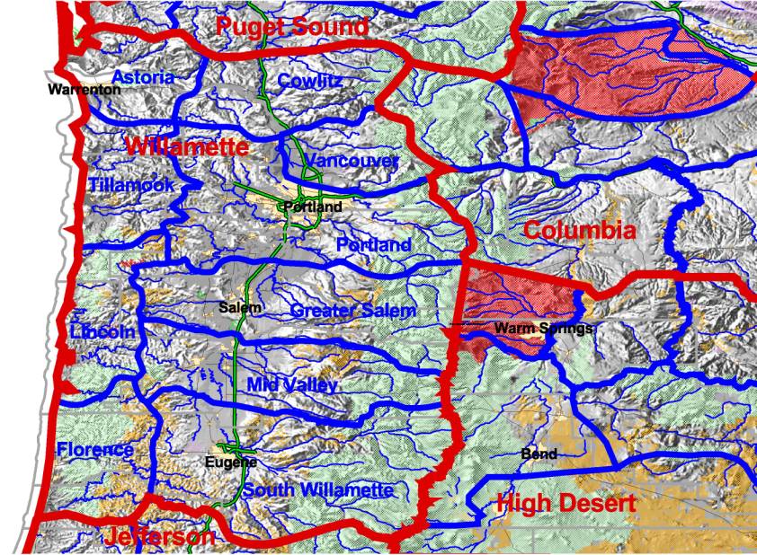
Social Resource Unit (SRU), as shown in Figure Two.


Human Resource Units (HRUs) are roughly equivalent in size to a county but seldom correspond to county boundaries. HRU boundaries are derived from the seven Cultural Descriptors outlined above. HRUs are characterized by frequent and customary interaction. They reveal face-to-face human society within which people have personal knowledge of each other and well-developed caretaking systems sustained through informal network relationships. People's daily activities occur primarily within their HRU including work, school, shopping, social activities and recreation. Health, education, welfare and other public service activities are highly organized at this level with a town or community almost always as its focal point.


Through this research, we also determined that there were three Human Resource Units (HRUs) that make up the targeted area, which we termed Greater Salem, Mid-Valley and South Willamette HRUs, also shown in Figure Two.
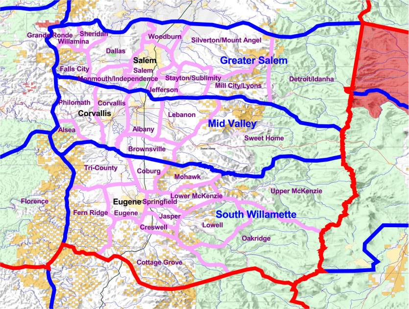
 

Community Resource Units (CRUs) show the "catchment area" of a community, or its zone of influence, beyond which people relate to another community (Figure Three). Geographic features or settlement patterns often determine these boundaries. At this scale, there is great face-to-face knowledge, and the caretaking systems through informal networks are the strongest. The three HRUs contain a total of 34 CRUs. Twenty-three of them have chapters here, while limited resources prevented description of the remaining eleven.


In addition to the qualitative research methods embodied in the Discovery Process, 2000 census data and available local information were used to augment the understanding of local communities.


The research, and the recommendations that accompany it, are structured in the GIS system of the Forest into what JKA calls a Human Geographic Issue


Figure Two

The Willamette Social Resource Unit (SRU) With Embedded

Human Resource Units (HRUs)


Figure Three

Map of the 34 Community Resource Units (CRUs) Contained in 

Three Human Resource Units (HRUs) in the Research Area


Management System (HGIMS) (tm). HGIMS is a system of access into the informal levels of society characterized by knowledge of informal networks, citizen issues, and human geography. We have found that this information can be visually displayed and is, in fact, highly amenable for inclusion into GIS.


Appendix A contains information about James Kent Associates (JKA). JKA has worked for over 30 years with natural resource agencies in the area of responsive management practices. Appendix B is an article describing the methods for the development of human geographic boundaries.


Organization of This Report


The Greater Salem HRU was found to have 14 CRUs, the Mid-Valley had 7 CRUs and the South Willamette had 13 CRUs. Community reports were completed for 23 of the 34 total CRUs. For CRUs without a report, the reader is referred to the report for the larger HRU area of which the CRU is a part. For example, a reader interested in the Sheridan CRU would find only a map in the GIS system, but could reference nearby CRUs like Dallas or Falls City or reference the Greater Salem HRU of which both Sheridan and Dallas are a part. Figure Three shows the CRUs contained in the research area.


This report contains a chapter for each of the HRUs - Greater Salem, Mid-Valley, and the South Willamette. They may be viewed as executive summaries of the CRUs contained within them, containing sections on major cultural descriptors, key findings related to community life, key findings related to public lands, and a summary of citizen issues related to public lands. The HRU reports are summaries of the CRU reports with one important distinction. The HRU reports also contain data from the 1990 and 2000 Censuses that have been downloaded into the HRU boundaries. In the view of JKA, this feature has enormous advantages.


First, both qualitative and quantitative data are integrated, thus containing not only the numbers that reveal baseline social and economic conditions, but also the meaning that local people have related to those numbers, and their ideas for improving their communities and environment. Second, rather than having county or regional data, that often have little bearing on the territory people actually use on a daily basis or identify with, data are aggregated to the natural human territory - the HRU. Hence, the real changes occurring in a community can be identified and worked with in a cultural context of change. Third, with the sub-regional variation of particular indicators being more readily obvious, a fine-tuned, tailored set of management options can be developed. For example, if one HRU is still focused on agriculture and forest products, it implies a different set of management prescriptions than an HRU that has shifted to retirement and recreation in its daily work routines. Figure Four contains a rationale and description of the census approach for the interested reader by our data analyst, Dr. Paul Zelus of Map Associates, Pocatello, Idaho.


The Community Resource Unit (CRU) reports contain three sections:

1) Baseline Social and Economic Conditions, obtained through descriptions by residents. This information is useful for forecasting change in a population by pending natural resource decisions, and for documenting existing conditions as required by many laws and regulations, the National Environmental Policy Act (NEPA) primary among them.
2) Communication Strategies employed by residents of the area, both informally through social networks and gathering places, and formally through organizations, agencies, and elected bodies. This information is helpful for management in maintaining dialogue with residents regarding Forest Service programs or projects. It also helpful for targeting information geographically, rather than relying on regional mass media approaches to communication, which necessarily must narrow and simplify the message to one or two items.

3) The Public Lands Perspective. This section is designed to summarize local interests as they relate to public lands. Often these interests are recreational, but they include forest products like timber and special forest products, and forest amenities like clean air and water, as well as a summary of current Forest Service/community ties. These are described from the perspective of local residents.


Figure Four

Cultural Areas, Census Data, and the National Resource Information Service

Paul Zelus, Ph.D.

September 1, 2002


Formulation by the US Forest Service of a Human Dimension Module (HDM) to its proposed National Resource Information System (NRIS) represents an opportunity to incorporate unique area typologies developed by James Kent Associates (JKA). While the Categories of Interest represented by Version 1 of the HDM are not exhaustive or complete, they do reflect some of the major variables and themes to be included in any such inventory.


Data sources that are at the same time national in coverage, available at some sub county unit of analysis, and for two or more points in time are very difficult to find. The decennial census of population and housing represents a unique opportunity to obtain and manipulate such data, which are available down to the census Block Group level of aggregation for both the 1990 and 2000 decennial censuses.


James Kent Associates utilizes a method for deriving units of geography built around cultural and social delimiters. They describe communities based on seven sets of descriptors including settlement patterns, work and recreation routines, and key geographic features. These areas - defined elsewhere as Human Resource Units, have specific geographic boundaries that can in turn be represented as aggregates of Block Groups, and have already been mapped by JKA for most of the western United States


By aggregating 2000 census data to the cultural resource units derived by JKA, an entirely new dimension and related set of data can be added to the HDM and NRIS.


An advantage of this approach is that it may be fully integrated into modern GIS environments, and thus may be displayed and manipulated locally.


Only a portion of the full range of variables and themes anticipated for inclusion in the HDM may be covered by decennial population data and therefore amenable to HRU aggregation. While census data represent one of the few sub county data sources covering the entire United States, other data sources at the county level of aggregation might also be suitably aggregated to the Human Resource Unit (HRU) and Social Resource Unit (SRU) levels.


In conclusion, recently released 2000 census information aggregated to cultural area defined previously by James Kent Associates should occupy a prominent place within the proposed National Resource Information System.


Included in this section are Themes, those perceptions and attitudes of residents toward public land management that are widespread in the population, but which are so general in nature that they cannot in and of themselves be acted upon by management.


The section also contains Citizen Issues, or statements residents make that can be acted upon. Citizen issues are crucial because they show where in the social system people are willing to take action to protect their interests and their community. They also show where partnerships and community-based initiatives are possible. Action taken around citizen issues has the best chance of creating citizen energy in solving problems in a way that empowers all parties. Issues, in short, provide management direction. Emerging issues can be resolved with management using the fewest resources. Disruptive issues, by contrast, are handled by higher levels of society and are lost to local resolution.


Finally, this section includes Management Opportunities for further communication and mutual action with citizens. This is the heart of the contribution made by this report and the interests contained in it. Opportunities, based as they are on the real issues of citizens, are the means to create proactive management. By definition, reactive management learns about issues too late and finds its opportunities limited. By identifying emerging issues and potential management opportunities, the agency is in a position to use its resources strategically to optimize its responsiveness.


In the CRU reports, we felt it was important to let people speak on their own behalf. For this reason, we made liberal use of quotes. While the hurried reader may thus skim the quotes, nevertheless, they provide rich information about how local people view the world and they offer an idea of the range of views on a particular topic. Note also that issues reflect the perceptions of residents. Residents may be misinformed about particular events or their level of scientific understanding about a topic may not be the same in all cases.


Readers are invited to focus on the geographic area most appropriate to their interest.

This project is reported for most readers on a CD-Rom. The CD contains a "Read Me First" file with detailed user instructions. Briefly, the CD has 3 formats: 1) An archive directory where each map and text file can be accessed in its own right; 2) Arc Explorer, which allows readers unfamiliar with ArcView an opportunity to use the reduced software capability to review the project, but with reduced manipulative capability. Arc Explorer allows the maps to be accessed in ArcView and has the capability of bringing up census data related to the map in question. Arc Explorer is not able, however, to bring up the text files associated with each map; and 3) Files in ArcView format are capable of being used by those with ArcView capabilities, including the personnel in the Willamette National Forest for which the project was designed.


The Theory of Social Ecology Applied to Forest Management

The Discovery Process and the Human Geographic Issue Management System are two methodological components in developing a social ecology approach to forest management. Social Ecology refers to the balance between people and the land characterized by a bio-social perspective. [2] There are four Propositions of Social Ecology:


  1. People everywhere develop an attachment to a geographic place characterized by a set of natural boundaries created by physical, biological, social, cultural and economic systems (a bio-social ecosystem).


  1. Unique beliefs, traditions, and stories tie people to a specific place, to the land, and to social/kinship networks. Informal networks and caretaking systems form the social capital by which communities sustain themselves.


  1. Since humans and nature rely on shared landscapes, the current status of "productive harmony" (NEPA balance of physical/social environments) must be described. The best opportunities for adaptive change are through the cultural alignment of the formal systems with the informal networks.


  1. Social ecology is thus not only a scientific enterprise (The Discovery Process - "What's out there?"),
  2. but an action methodology (Human Geographic Issue Management Systems - "What do I do with it?") that
  3. builds citizen and institutional capacity for creating and enhancing healthy environments.


  Figure Five


Figure Five shows a bio-social model of ecosystem management based on the principles of social ecology, with the goal of productive harmony as called for in the National Environmental Policy Act (NEPA). It indicates that the qualities of persistence and diversity are managed for in both the physical and social environments in order to foster sustainability (Preister and Kent 2001). [3]


The capability of a Human Geographic Issue Management System (HGIMS), as reported in this project, is to position the agency for proactive management that fosters:


Responsive management practice to citizen issues;

Ongoing dialogue and education between agency and citizens about mutual interests;

Collaborative, community-based approaches to management and projects; and,

Project and policy development responsive to changing social, economic, and ecological conditions.


The intent of JKA is that Forest Service and BLM staff will use the HGIMS in active management ways for day-to-day management, project development and implementation, as well as educational and policy initiatives. The uses are these:


  1. The CRUs reveal boundaries within which people mobilize already to solve life's problems. If a proposed project is on a CRU line, it means that people within two CRUs need to be involved. The management goal is to resolve citizen issues related to a new proposal at the CRU level if possible to avoid its escalation geographically. The CRUs also allow targeted response and management for the unique aspects, goals and values of each area.


  1. The HGIMS identifies existing conditions and citizen issues so that agency personnel can anticipate likely consequences and responses to management initiatives.


  1. The HGIMS indicates communication strategies for each CRU so that ideas about who to communicate with, as well as where and when, can be part of an intentional effort of direct citizen contact. Enormous benefits accrue to management in engaging in citizen contact outside of formal public meetings. Goodwill is created and opportunities remain broad.


  1. As the decision process proceeds, ongoing dialogue at strategic moments, especially with the identified caretakers, precludes the perception of "black box" management in which input is obtained but people never hear from the agency again until decision. The goal is to create citizen ownership so the public language is "our project" and not just an agency project. Attention to emerging issues, as opposed to existing or disruptive issues, is the single best way to create citizen ownership.


Staff Training and Coordination with the Siuslaw and Willamette National Forests

Patti Rodgers, Public Affairs Specialist on the Willamette National Forest served as Project Coordinator for the Forest. JKA made several presentations about the project over the last several months, including to:


In addition, both project openings and closings were held with the many field offices in the area, including the Supervisor's Offices of both Forests, and the ranger districts of Detroit, Sweet Home, McKenzie, and Middle Fork, as well as the Cottage Grove district of the Umpqua National Forest.


Several staff members from the two forests participated n the research from one to seven days. We want to thank them for their contribution:


Julie Cox

Cara Kelly

Sue Olson

Gina Owens

Joni Quarnstrom

Phil Raab

Mike Rassbach

Dani Rosetti

Carol Winkler


Glossary of Terms


BLM - Bureau of Land Management, Department of the Interior

EPA - Environmental Protection Agency

FS - Forest Service

GIS - Geographic Information system

GPS - Geographic Positioning System

JKA - James Kent Associates

NRCS - Natural Resource and Conservation Service

ODF - Oregon Department of Forestry

ODOT - Oregon Department of Transportation

OECD - Oregon Department of Economic and Community Development

OSU - Oregon State University

OWEB - Oregon Watershed Enhancement Board

USDA - U.S. Department of Agriculture

USFS - United States Forest Service

WOU - Western Oregon University


[1] Kent, James A., J.D., Kevin Preister, Ph.D., "Methods for the Development of Human Geographic Boundaries and Their Uses", in partial completion of Cooperative Agreement No. 1422-P850-A8-0015 between James Kent Associates and the U.S. Department of the Interior, Bureau of Land Management (BLM), Task Order No. 001, 1999

[2] Preister, Kevin, Ph.D. and James A. Kent,  "Social Ecology: A New Pathway to Watershed Restoration."  in Watershed Restoration: Principles and Practices, by Jack E. Williams, Michael P. Dombeck and Christopher A. Wood, Editors. Bethesda, Md.: The American Fisheries Society, 1997.

[3] Preister, Kevin, Ph.D., and James A. Kent, J.D., "Using Social Ecology to Meet the Productive Harmony Intent of the National Environmental Policy Act (NEPA)", Hastings West-Northwest Journal of Environmental Law and Policy, Volume 7, Issue 3, Spring, Berkeley, CA.: Hastings College of the Law, 2001.

                              Table of Contents Next Chapter   
Natural Borders Homepage